| 
                         Where: Blackcraig Hill, by New Cumnock,
                        Ayrshire 
                        When: March 27th 2012 
                        Who: I Parker 
                        Why: good weather so a day out to take some
                        photos 
                        Weather: Sunny about 20c/ 70f unusually
                        warm for time of year 
                        Distance: ? miles 
                        Blackcraig Hill is a popular walk as it
                        is one of the highest hills in Ayrshire at
                        2,296 feet above sea level, if not the
                        highest. The area is about 800 feet above
                        sea level so the actual hike should be
                        about 1,400 ft. There are another three
                        hills next to Blackcraig, one over 2,000 ft
                        and the others just below 2,000 ft. Many
                        people want to go round the four hills. 
                        Finding Blackcraig Hill is the first
                        thing to do. Travel to the town of New Cumnock
                        in East Ayrshire. On the south side of the
                        town following the A76, you will see a
                        small roundabout with a turn left to
                        Dumfries, and a turn right to
                        Dalmellington. Take the road to
                        Dalmellington and after only 50 yards, you
                        will see the sign below pointing to Afton
                        Road, Camping and Burns Cairn. Blackcraig
                        Hill is about 4 miles down Afton Road. 
                        Road
                        Map 
                       | 


                      | 
                         After 4 miles down Afton Road, you will
                        see a narrow farm road lead off to the left
                        with a small bridge crossing Afton Burn
                        (Afton Water). The hill in the distance
                        below is Blackcraig. Just before the burn
                        is parking for about two cars only.
  
                       | 


                      | 
                         From the car park, as seen below, you
                        can see the Blackcraig Farm road leading up
                        to the north side of Blackcraig Hill. You
                        then cross a field and work your way up
                        onto the main hill. This is probably the
                        steadiest way up, but if the car park is
                        full, or you want a stiffer challenge,
                        drive on about another mile to a larger
                        carpark by the west side. 
                        There are no trails to follow, so it is
                        over moorland with some soggy patches here
                        and there, so hiking boots are essential.
                        These are sheep farms, so best not take a
                        dog, or, keep them on a lead. 
                       | 


                      | 
                         About 1 mile further down Afton Road,
                        you pass a small farm, then about 200 yards
                        further on are two cottages with parking in
                        front of them, as seen below next to two
                        storage units. This view below shows
                        Blackcraig Hill steep west side. 
                       | 


                      | 
                         The map below shows the different routes
                        to hike Blackcraig Hill, and the three
                        hills on the same range, Blacklorg Hill at
                        2,234 ft, Cannock Hill at 1,948 ft, and
                        Craigbraneoch Rig at 1,889 ft. 
                        There are two steep routes onto this
                        range, one up the west side of Blackcraig
                        Hill following a gully, and one up the
                        north side of Craigbraneoch Rig. 
                        The photo tour below is going up the
                        steep north side of Craigbraneoch Rig,
                        round the four hills, then down the steep
                        west side of Blackcraig Hill. 
                       | 


                      | 
                         Below are a few images with information
                        of the four hills going anti-clockwise from
                        Craigbraneoch Hill round to Blackcriag
                        Hill. 
                        At Craig Farm, you take the road south
                        round towards Craigbraneoch Rig, the one
                        with the peak, as seen below. 
                       | 


                      | 
                         The direct rout is up the north side, a
                        steep testing hike that is good and dry.
                        The view below is from just over half way
                        up the north side. Once you have walked
                        about 1 third of a mile along the forest
                        path, as seen bottom right, and are level
                        with the start of the north side, you can
                        follow a fence from the path that leads to
                        a gate. The gate leads to this route up.
                        Best only go up or down this route in good
                        visabilty, as there are a few cliffs either
                        side. 
                       | 


                      | 
                         The summit of Craigbraneoch gives views
                        over Afton Dam and the 1,948 feet Cannock
                        Hill to the south, the next peak. 
                       | 


                      | 
                         From close to the top of Cannock Hill,
                        looking back north, you get good views of
                        Afton Dam/Reservoir as seen below. This
                        view also shows Craigbraneoch south and
                        west sides are an easy hike compared to its
                        steep north or east sides. The route across
                        is a bit soggy at the lowest point, but
                        nothing too bad. 
                        There are walking signs from the top of
                        the Dam that point to a path through the
                        trees, out onto the side of Craigbraneoch.
                        You have to climb a hundred or two steps to
                        get up to the top of the Dam, then it is
                        only about half of an hour from the top of
                        the dam to Craigbraneoch summit, good dry
                        hiking. The safest and quickest way up or
                        down. 
                        Large
                        Image 
                       | 


                      | 
                         The summit of Cannock Hill, as seen
                        below looking east, shows the next peak,
                        Blacklorg Hill at 2,234 feet, 286 feet
                        higher than this peak. 
                       | 


                      | 
                         The view below is when crossing over at
                        the end of the glen showing Craigbraneoch
                        Hill left and Blackcraig Hill right. 
                        Large Image
                        looking up the glen. 
                       | 


                      | 
                         The view below is after crossing from
                        Cannock Hill to Blacklorg Hill. The walk
                        down and across was easy going and dry,
                        just this hike up was a bit testing. 
                       | 


                      | 
                         The view below is from the side of
                        Blacklorg Hill looking up Afton Glen.
                        Large
                        Image 
                       | 


                      | 
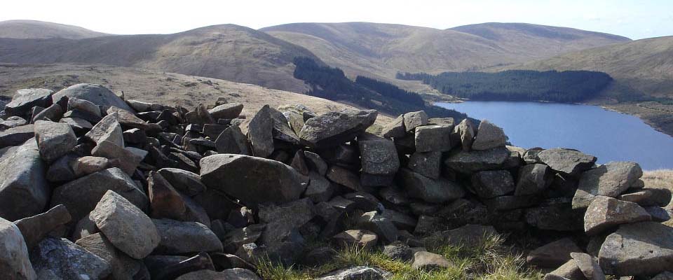
                         The view below is from Blacklorg Hill
                        summit looking north to Blackcraig Hill at
                        2,296 feet, 62 feet higher than this
                        one. 
                       | 


                      | 
                         The view below shows the south side of
                        Blackcraig Hill after descending from
                        Blacklorg Hill. Its about 500ft down then
                        back up. This low area is a bit soggy in
                        places, nothing too bad though. Large
                        Image. 
                       | 


                      | 
                         The view below shows Blackcraig Hill
                        south side when aproaching the summit. The
                        two hikers here are going round the four
                        hills clockwise, starting from Blackcraig
                        Farm at the north side. Large
                        Image. 
                       | 


                      | 
                         The view below shows Blackcraig Hill
                        summit from the south side. 
                       | 


                      | 
                         The view below shows Blackcraig Hill
                        summit looking north towrds New Cumnock.
                        There are three ways down from here, head
                        north towards the Wind Farm and down
                        towards Blackcraig Farm, head north then
                        follow a stone dyke down the north
                        shoulder, or go down the steep west side
                        following a narrow gully. 
                        Large
                        Image. 
                       | 


                      | 
                         Following the gully down or up the steep
                        west side is best only done when visibility
                        is good, as there are high drops not far
                        off eaither side of the gully. This route
                        gives the best views though, and is the
                        fastest. One hiker claimed to have hiked up
                        this route in about 1 hour. 
                        Large
                        Image. 
                       | 


                      | 
                         The view below shows the gully where you
                        have to cross over for the best way
                        down. 
                       | 


                      | 
                         The view below is from the bottom of the
                        gully showing there is a little rock
                        climbing to be done, but nothing
                        difficult. 
                       | 


                      | 
                         Crossing Afton Burn to get back to the
                        car park is normally easy, but watch out
                        for wet stepping stones. If it has been
                        wet, and you do not fancy crossing the
                        burn, you can follow the burn up to
                        Blackcraig Farm where there is a
                        bridge. 
                       | 


                      | 
                         The view below shows the gully going up
                        the west side of Blackcraig Hill. There is
                        a stone dyke that leads up onto the north
                        shoulder of the hill towards the wind farm,
                        that is not as steep and safer. 
                        Once you cross the burn it is through a
                        field up to the road here and car park at
                        the two cottages. 
                       | 


                      | 
                         These are good hills to hike with not
                        too many wet spots, and a fairly good road
                        right to the bottom of them. 
                        From the road leading to the dam, just
                        past the dam car park, there is a marked
                        trail that leads up onto the hill named
                        Windy Standard at 2,290 ft. This hill has a
                        wind farm on it. 
                        Short Video
                        of the four hills, the part up between
                        Cannock and Blacklorg is a great view. 
                       | 


             | 
           
         
       |